Deer, cattle and timber: Anglo-Norman parks in medieval Ireland: 1169-c.1350.
- Staff member: Dr Fiona Beglane (PI).
- The aim of this project is to examine the evidence for high medieval parks in Anglo-Norman Ireland. It has culminated in the publication of a recent book: Anglo-Norman Parks in Medieval Ireland. This is the first study on the subject of medieval parks in Ireland. It concentrates on parks documented in the period 1169 to c.1350, but also discusses what happened to these in later times. It adopts an interdisciplinary approach drawing upon archaeological fieldwork, historical and place name evidence in order to generate a broad understanding of the role of parks in medieval landscapes and society. The research is underpinned by extensive fieldwork which has identified surviving park features in the landscape. Fallow deer were introduced to Ireland by the Anglo-Normans, specifically to be stocked in parks, so that they are intrinsically linked to the role of parks. Notably, the evidence suggests that both parks and fallow deer appear to be relatively uncommon in Ireland compared to England. This raises the questions that if a park was an essential manorial feature in England, and if the English manorial system was transposed to Ireland, then why are there so few records of high medieval parks in Ireland? Furthermore, why are there so few fallow deer remains in Ireland and why did fallow deer ownership not filter down the social ladder? The answers to this question lie in chronology, landscape and politics and form a major theme within this research.
|
 |
Staad Abbey Coastal Erosion Survey.
- Staff member: Dr Fiona Beglane (co-PI). Collaborator: Jerry O’Sullivan (co-PI).
- Staad Abbey, Co. Sligo is a medieval church site with associated middens and archaeological features situated on a low cliff face adjacent to the sea. The eroding middens were originally surveyed and sampled by Dr Finbar McCormick in 1993 (93E0110). Subsequently he and Jerry O’Sullivan excavated and re-recorded on the site in 2000-2001 (00E0235 and 00E0235 ext). The aim of this current project is to assess the effects of coastal erosion on the cliff-face middens at this vulnerable site in the intervening time and so gain a multi-decadal insight into the ongoing destruction of the archaeological features. In June 2012 a group of student volunteers undertook the re-recording of the cliff face and the church building and analysis of the results is ongoing.
|
 |
Landscape Histories: Perceptions of the Past in North Connacht 8000BC to AD 2010.
- Staff Member: Chris Read (PI). Funded by IT Sligo. Collaborators: UCD School of Archaeology.
- This interdisciplinary, multi-period study of a substantial area in Connacht, including North County Roscommon and South County Leitrim is being undertake as a PhD study. This GIS based study will analyse the placement of over 2500 monuments and other significant sites within the study area. Interpretively, this study will focus on social memory and how people in the past, perceived the traces left behind by earlier generations. This research will combine archaeology, history, folklore and cultural anthropology and incorporate the findings from a number of sites from all periods excavated by the author.
|
 |
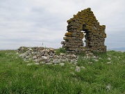
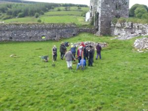
Moygara Castle Archaeological Project.
- Staff members: Chris Read (PI) and Shirley Markley. Funded by IT Sligo. Collaborators: NUIG Archaeology, O’Gara family, P.J. O’Neil.
- The site of the new IT Sligo archaeological field school, this 14th-17th century castle will be the subject of a 5 year excavation to explore the dating and use of this beautifully preserved castle overlooking Lough Gara. This castle has already been subjected to extensive architectural and historical research by Jason Bolton, Rory Sherlock, Ann Connan and Kieran O’Conor. Test excavation in 2013 involved the opening of 4 small trenches. They revealed medieval deposits, wall foundations and evidence of iron working. Larger scale excavation took place in 2014 and 2015. This site is the student training excavation for all first year students and is also run as a Field School. This is open to students and non-students from both Ireland and overseas.
|
 |
Fenagh Archaeological Project.
- Staff Member: Chris Read (PI). Funded by Heritage Council.
- Focusing on the multi-period archaeological landscape surrounding this monastic site in Co. Leitrim, this project has focused on the survey of the Monastic site and a study of the wider surrounding landscape. This project has so far included historical research, topographical survey, geophysical survey and low level aerial photography. This landscape will be further explored and analysed in the ‘Landscape Histories’ project.
|
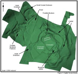 |
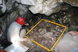
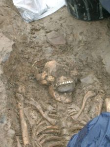
Kilteasheen Archaeological Project.
- Staff members: Chris Read (co-PI), Shirley Markley and Dr Fiona Beglane. Collaborator: Dr Thomas Finan (co-PI), Saint Louis University. Funded by Royal Irish Academy, Heritage Council and IT Sligo Capacity Building Fund.
- This multi period site at Kilteasheen was the subject of a 5 year research/training excavation. This site has prehistoric (principally Later Bronze Age), Early Medieval and Later Medieval components. The excavation portion of the project focused on a 13th century hall house, believed to be the Bishop’s palace mentioned in the annals and the partial excavation of a substantial medieval cemetery. This cemetery revealed burials dating from the 7th to 14th centuries AD and include a number of deviant burials that were the focus of a National Geographic television documentary. Research and analysis on these burials in ongoing. A final round of C14 dating will be undertaken shortly. Most recently, a number of the Kilteasheen burials will be subject to innovative DNA analysis in an attempt to identify a range of diseases suffered by this medieval population. This research is being carried out in conjunction with Professor Johannes Krause at Tubingen University.
|
 |
Place, time and meaning: the Carrowkeel/Keshcorran passage tomb complex, Co. Sligo, Ireland.
- Staff member: Sam Moore. Funded by IT Sligo. Collaborator: NUI Galway.
- This is a prehistoric archaeological landscape PhD thesis employing a methodological focus on the spatial patterning, morphology and landscape siting of the passage tomb complex along with its spatial and temporal relationship with the surrounding landscapes. Concepts of networks, nodes and place are utilised in conjunction with natural and built features with the principle aim being to examine potential changes in ritual practise and the meaning of monuments throughout the Neolithic specifically and prehistory in general, therefore aiding an understanding of prehistoric people’s relationship to their physical and symbolic landscape.
|
 |
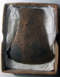
Bewitched by an elf dart: the reinvention of archaeological artefacts in modern Ireland.
- Staff member: Dr. Marion Dowd (PI). Funded by IT Sligo.
- In recent centuries archaeological artefacts were frequently interpreted by rural communities in Ireland as the material culture of the sídh, physical evidence of the existence of a non-Christian supernatural world. These artefacts – typically Bronze Age metalwork, prehistoric lithics and polished stone axes – were attributed both malevolent and benevolent properties and assumed an important role in popular religious practices, most frequently to invoke cures for farm animals, though also to protect the house. Numerous examples are recorded and while the tradition has been documented in folklore scholarship, it is not widely known or recognised in archaeological discourse. This project seeks to examine the phenomenon from an archaeological perspective by examining a series of multi-period artefacts that were discovered in the ruins of vernacular houses and farm outhouses which appear to support the documented folk traditions.
|
 |
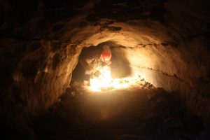
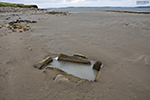
Fighting the tide: a saltwater fulacht fiadh on Coney Island
- Staff members: Dr. James Bonsall and Dr. Marion Dowd.
- In conjunction with Ned Kelly of the National Museum, we excavated the trough of a fulacht fiadh located on the beach at Coney Island in Sligo Bay in 2014. Radiocarbon dating places the construction of the monument in the Late Bronze Age, a typical date for stone-lined troughs like this example. More intriguing, however, is the evidence that the site was used for heating salt water. Whether this was used for washing, bathing, cooking or otherwise is not known
|
 |
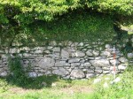
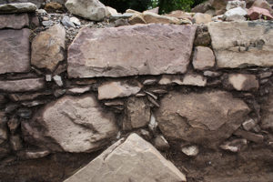
Earth Built and Earth Mortared Masonry Construction in Later Medieval Ireland 1100-1650AD
- Staff members: Shirley Markley. Funded by IT Sligo. Collaborators: School of Histories and Humanities, Trinity College Dublin
- The veritable absence of domestic settlement from the late medieval archaeological landscape in Ireland has posed an enigma to medieval archaeologists and historians to date. This doctoral research examines and documents the evidence of earth built and earth mortared masonry construction in later medieval Ireland, a subject which has previously gone unexplored in Ireland. Previously thought to be used in the construction of primarily post medieval dwellings and agricultural buildings as well as utilised by the poorest classes in society, this study points to significant new interpretations on the subject of late medieval settlement. Substantial regional field survey of over 300 late medieval high status structures in Counties Sligo, Leitrim and Roscommon combined with field survey in ancillary counties provides considerable evidence for the use of earth in construction both on its own and as an earth mortar in masonry construction. This construction technique is evidenced across a range of building types including ecclesiastical, defensive, industrial, infrastructural and importantly domestic settlement in the later medieval settlement record. Extensive regional field survey combined with comprehensive documentary evidence, from both historical sources and archaeological excavation reports, illuminates a method of traditional building construction in later medieval Ireland that has previously gone largely unrecognised and greatly underappreciated within Ireland
|
 |