Arghadyuti Banerjee
Current PhD Student
Tracking dynamic time-dependent groundwater vulnerability using satellite scatterometer observations, lowcost sensing technologies and land-use stochastic models
The main aim of this research project is to develop a framework/Decision support tool that will generate different probabilistic groundwater contamination scenarios considering nitrate as an indicator. A state-of-the-art risk monitoring system could enhance preparedness capability among all the stakeholders. Giving the spatial nature of groundwater-related data and their time component, effective groundwater resource management (GWRM )requires the application of methods and software tools pertaining to the Information and Communication Technologies (ICT) sector such as spatial data management, real-time data collection & numerical modeling, The research aims to map hazardous areas by integrating remote sensing, GIS and statistical methods to assess the efficacy of land use planning toward groundwater protection.
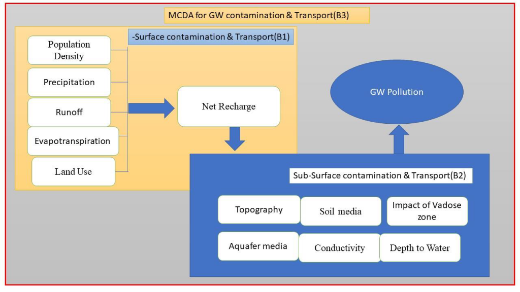
Figure. Impacts of anthropogenic and Natural changes on Groundwater
Profile: I am a doctoral student in the School of Engineering of IT Sligo. I hold a Bachelor’s degree in Geography and Master’s degree in Remote Sensing and GIS. My main research focus concentrates on how to deal with the pragmatic socio-environmental issues for the betterment of environmental and social health. My research interests include biodiversity, natural hazards, climate change, land use change, environmental degradation and natural resources. I’m having a strong background in earth observation systems and Geographic Information System (GIS) applications. For my master’s thesis, I wanted to get better understanding of the impact of a tropical cyclone (‘Aila’) on deltaic environment as well as on socio-economy. Before joining IT Sligo for my doctoral research programme, I have worked with many research and development organisations in India (CSIR-IHBT, Forest Survey of India, CSIR-NISCAIR and CSIR-CRRI) and gained knowledge in the field of remote sensing data analysis, geospatial technology and big data handling. Currently I am pursuing my PhD research on groundwater contamination under the supervision of Dr Salem Gharbia and Dr Leo Creedon at IT Sligo.
Research Interests: Natural environment and society, Remote Sensing and GIS, Climate change, Natural hazards.
Contact: arghadyuti.banerjee@nullmail.itsligo.ie
Projects handled:
- An assessment on Physico-cultural status of selected blocks of Sundarban at post Aila phase using geo-informatics techniques.
- Bioresource Inventorization with a focus on bioprospecting of Pteridophytes of Western Himalaya.
- Vulnerability Assessment and Development of Adaptation Strategies for Climate Change Impact with Special Reference to Coasts and Island Ecosystems of India.
- Multi-criteria Based Landslide Hazard Evaluation Study Using Spatio-temporal Data- A case study of Munnar Watershed, India
Profile Links:
https://www.researchgate.net/profile/Arghadyuti-Banerjee
https://www.linkedin.com/in/arghadyuti-banerjee-45aa4462/
https://scholar.google.com/citations?user=T3YjP0gAAAAJ&hl=en